
Royal Fortresses of Languedoc: Carcassonne and the Mountain Sentinels
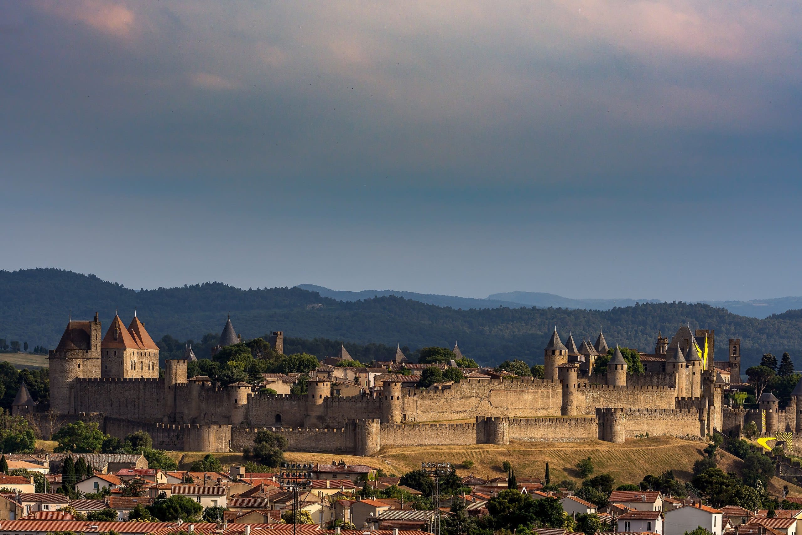
The Royal Fortresses of Languedoc are eight medieval strongholds strung across the far south of France, from the walled city of Carcassonne to a line of cliff-top castles that watch the passes toward the old border with Aragon. For most of the twentieth century they were sold to visitors as Cathar castles, romantic refuges of a persecuted faith. The truth is harder, and in its own way grander. The people who built and rebuilt these walls were not heretics but agents of the French crown, and the fortresses were instruments of conquest, raised to hold a frontier the king had only just taken by force.
In January 2025 France submitted them to UNESCO as a single serial property and asked the world to retire the Cathar label for good. It worked. On 26 July 2026, at its session in Busan, South Korea, the World Heritage Committee inscribed all eight on the World Heritage List under criteria (ii) and (iv), as the Royal Capetian Fortresses of Languedoc. The nomination dossier had carried a drier scholarly title, the System of Fortresses of the Seneschalty of Carcassonne, while the campaign ran under the shorter public name that heads this guide. This guide gathers the six that StoneKeep Atlas covers in depth: Carcassonne, the fortified capital of the system; Peyrepertuse, the largest of the mountain sentinels; Quéribus, the last to fall; and the sentinels of Termes, Puilaurens, and Lastours, each with a full guide of its own. Between them they carry the argument the whole nomination is built on, a heretic frontier remade into the king’s impregnable southern wall.
The Royal Fortresses of Languedoc at a Glance
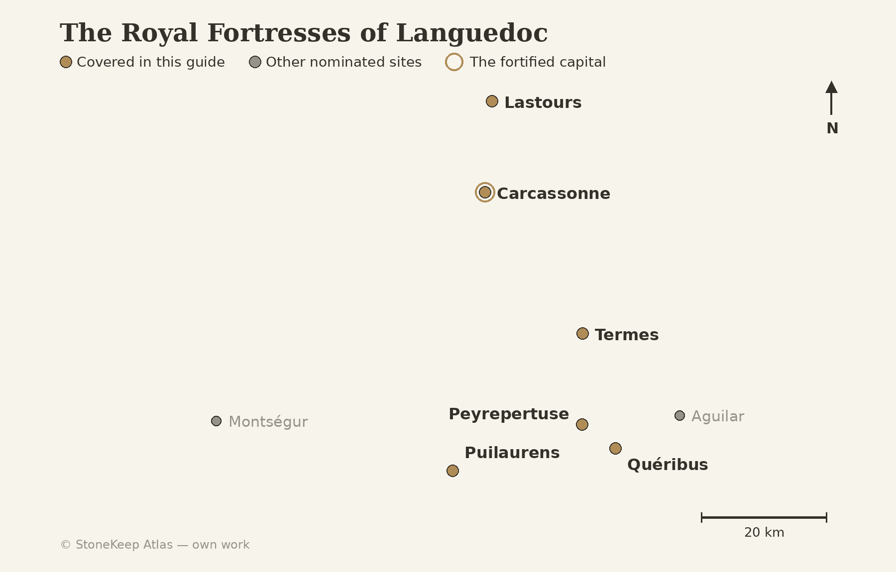
Eight sites make up the property: the city of Carcassonne and seven castles scattered through the hills and mountains of the Aude and the Ariège. Five of those castles, Aguilar, Peyrepertuse, Puilaurens, Quéribus, and Termes, are traditionally called the Five Sons of Carcassonne, the frontier sentinels that guarded the line against Aragon. Lastours and Montségur complete the set. The table below places the six fortresses in this guide against the system as a whole.
| Fortress | Role in the system | Origin and royal rebuilding | Setting | UNESCO |
|---|---|---|---|---|
| Carcassonne | The fortified capital | Roman walls 3rd–4th c.; royal ramparts 13th c.; restored from 1853 | Walled city above the Aude | Inscribed 1997 (the Cité); inscribed 2026 (serial) |
| Peyrepertuse | The great cliff sentinel | Catalan castle 11th–12th c.; Sant Jòrdi keep 1250–51 | About 800 m ridge, Corbières | Inscribed 2026 (serial) |
| Quéribus | The last redoubt | First recorded 1020; rebuilt for the crown, late 13th–14th c. | 728 m peak above Cucugnan | Inscribed 2026 (serial) |
| Termes | The gorge sentinel | Seigneurial castle 10th–12th c.; royal fortress 13th c.; demolished 1653–54 | About 460 m, Corbières gorges | Inscribed 2026 (serial) |
| Puilaurens | The best-preserved sentinel | Castrum 10th–13th c.; royal fortress after 1255 | 697 m on the Mont Ardu, Fenouillèdes | Inscribed 2026 (serial) |
| Lastours | The four-castle ridge | Three castles by the 11th c.; royal reconstruction after 1229 | Rock crest at 260–285 m, Montagne Noire | Inscribed 2026 (serial) |
Plotted together, the eight trace the shape of a vanished border. Carcassonne sits out on the plain as the command center, while the sentinels climb south and east into the Corbières and the Pyrenean foothills, each commanding a pass or valley along the old frontier.
How a Crusade Became a Frontier
The fortresses make sense only against the war that produced them. In 1209 Pope Innocent III launched the Albigensian Crusade against the Cathar heresy that had taken root in the Languedoc, and an army of northern French barons swept south under the papal legate. Carcassonne fell that same summer, and its young viscount, Raymond-Roger Trencavel, died a prisoner in his own castle within months; command of the crusade then passed to Simon de Montfort, who set about subduing the rest of the country. Twenty years of campaigning broke the independent lords of the south, and the Treaty of Paris in 1229 folded their lands into the French royal domain.
What followed was occupation rather than reconciliation. The crown had inherited a hostile, half-conquered country whose old nobility was dispossessed, and beyond it lay the Crown of Aragon, which still held lordships on both slopes of the Pyrenees. To secure the new frontier, Louis IX and his successors took the strongest of the captured castles and rebuilt them as royal fortresses, garrisoned by the king’s own men. The Treaty of Corbeil in 1258 then drew the border with Aragon along the southern foot of these mountains, and the line the fortresses would watch for the next four centuries was fixed.
Carcassonne: the Fortified Capital
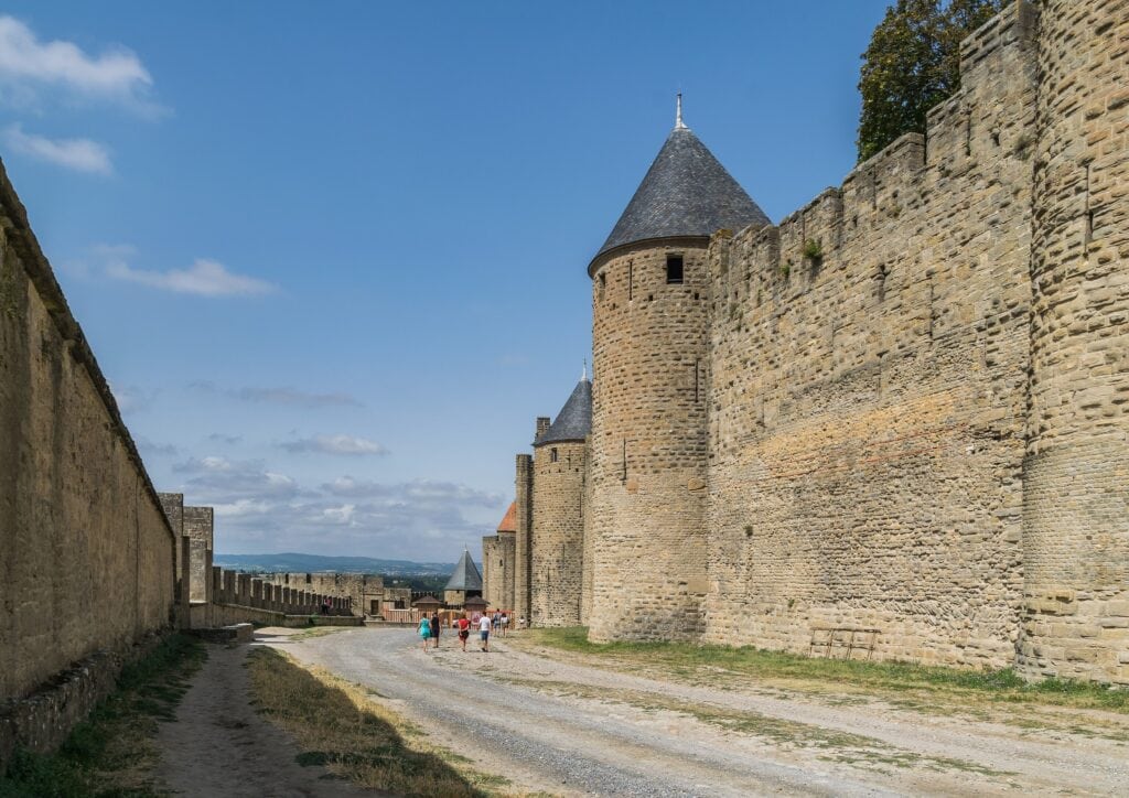
Carcassonne is where the system begins. The double ring of walls that crowns the hill above the river Aude makes it one of the most complete fortified medieval cities in Europe, fifty-two towers set along nearly three kilometers of rampart, and it was the seat from which the French crown governed the conquered Languedoc. A Gallo-Roman fortress stood here first; the inner castle, the Château Comtal, went up around 1130 under the Trencavel viscounts; and after the city fell to the Albigensian crusaders in 1209, Louis IX and his son Philip III the Bold threw the outer ring of ramparts around it in the thirteenth century, doubling the walls and making the place all but impregnable. When the dispossessed Trencavel heir, Raymond II, tried to retake the city in 1240 and failed, the king answered by strengthening the walls once more and clearing the houses that had crowded against them, founding the lower town across the Aude where the displaced residents resettled. From the Cité, a royal seneschal governed the whole conquered march.
By the nineteenth century the Cité had decayed into a crowded slum and was very nearly pulled down. What saved it was a restoration, begun in 1853 under the architect Eugène Viollet-le-Duc, so sweeping that it became controversial in its own right. When UNESCO first weighed the city in 1985 it actually hesitated, deferring the nomination in part because the monument had been so heavily rebuilt. It reconsidered, and in 1997 inscribed the Historic Fortified City of Carcassonne on the World Heritage List, citing both the medieval defenses and the restoration that had rescued them.
That 1997 listing stands on its own. The 2026 serial inscription recognizes something wider: Carcassonne not as a lone monument but as the anchor of a military network, the capital whose garrison and authority reached out to the sentinel castles in the hills. In the serial property the Cité is the head, and the mountain fortresses are the limbs. Our full guide to Carcassonne Castle follows the city from Roman wall to Viollet-le-Duc in detail.
Peyrepertuse: Celestial Carcassonne
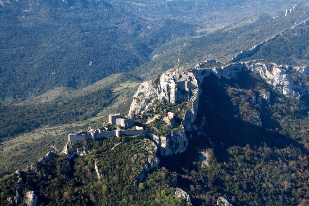
If Carcassonne is the capital, Peyrepertuse is its grandest outpost. The fortress runs along a limestone ridge some eight hundred meters above sea level in the Corbières, its walls hugging the rock so closely that from the valley it is hard to tell where the cliff ends and the masonry begins. It is the largest of the Five Sons of Carcassonne, and because its footprint rivals that of the Cité itself, it has long carried the nickname Celestial Carcassonne.
The lower castle began as a Catalan stronghold, held by the counts of Besalú and first noted in records around the eleventh century. It became French only after the failed siege of Carcassonne in 1240 forced its lord to submit. Louis IX then made it royal: between 1250 and 1251 his masons raised the Sant Jòrdi keep on the highest point of the ridge, reached by a staircase cut into the bare rock, and turned a feudal castle into a frontier fortress.
The Treaty of Corbeil, signed in 1258, fixed the border with Aragon just south of this ridge, and Peyrepertuse spent the next four centuries watching it. What survives today is remarkably complete for an abandoned mountain stronghold: the great enceintes, both keeps, the rock staircase, and a small Romanesque chapel, all still legible against the sky. The Château de Peyrepertuse guide walks the full circuit from the lower gate to the Sant Jòrdi keep.
Quéribus: the Last Redoubt
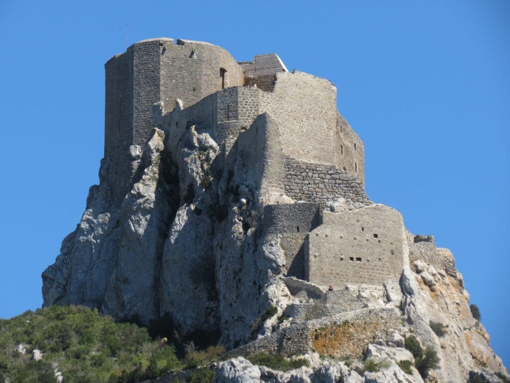
Quéribus stands on the highest peak for miles around, a single keep and its enclosures balanced on a rock at 728 meters above sea level, high above the village of Cucugnan. It is the easternmost of the Five Sons, and it holds a particular place in the region’s memory as the last stronghold linked to the Cathars to pass under royal control.
After Montségur fell in 1244, surviving believers are said to have drifted to these border castles, beyond the easy reach of the French king. Quéribus held out until 1255, when its defender, Chabert de Barbaira, gave it up to a royal force whose conduct was credited to Olivier de Termes, a local lord who had once fought against the crusade and later served the king. No great assault is recorded; the castle changed hands by negotiation, or perhaps betrayal. Its surrender closed the military chapter of the Cathar story in the mountains.
Under the crown Quéribus was rebuilt as a proper fortress, the work running on into the fourteenth century. At its heart is a polygonal keep, and inside that, a vaulted Gothic hall lit by a single tall mullioned window, a room of unexpected refinement for so wild a perch. Like its neighbors it lost its purpose in 1659 and slid toward ruin, rescued only by restorations that began in the twentieth century. Our Château de Quéribus guide covers the climb, the hall, and the long Cathar afterlife.
Termes, Puilaurens, and Lastours: the Sentinels Completed
Three more of the mountain sentinels now carry full StoneKeep Atlas guides. The Château de Termes holds a wild knot of the Corbières where Simon de Montfort needed a four-month siege in 1210, a fight that earned a name as the hardest of the crusade’s opening years; the crown kept the rebuilt fortress garrisoned for four centuries and then deliberately demolished it in 1653 and 1654. The Château de Puilaurens, remade as a royal fortress after 1255 on its 697-meter crag in the Fenouillèdes, is often described as the best preserved of the Aude citadels, its walls and crenellations still climbing the Mont Ardu much as the king’s builders left them. And the Châteaux de Lastours are four castles in one: Cabaret, Tour Régine, Surdespine, and Quertinheux, strung along a single knife-edge of rock in the iron country of the Montagne Noire, largely a royal reconstruction of the later thirteenth century raised after the crown crushed the local lords.
Together they carry the same lesson as the great set-pieces above: what stands on these summits is mostly the victors’ work, the king’s frontier in stone. Six of the eight inscribed fortresses now have full guides on StoneKeep Atlas, each telling one stretch of that frontier, from the gorge road at Termes to the passes of the Fenouillèdes and the northern approaches through the Montagne Noire.
Beyond the Six
Two of the eight inscribed sites lie beyond the scope of this guide. Aguilar, low and ringed by vineyards near Tuchan, is the last of the Sons of Carcassonne still awaiting a StoneKeep Atlas guide of its own, and Montségur, the lonely Ariège summit where the Cathar church made its last stand in 1244, rounds out the eight; its story is told from the Cathar side in its own guide.
One famous neighbor is deliberately absent. The Château de Foix, seat of the counts who once ruled much of this country, is a flagship of Cathar Country tourism, yet it is not one of the eight Royal Fortresses; it belongs instead to a separate UNESCO bid built around the co-principality of Andorra. It is well worth the detour from the fortress road, on its own quite different terms.
These same castles can be read another way. Our companion hub, the Cathar Castles, follows them as the human story of the Albigensian Crusade, the faith and the people who defended it, where this guide tells the military story of the frontier. Both belong to the national map drawn in our guide to the Châteaux of France.
Planning a Visit to Cathar Country
The fortresses sit within an hour or so southeast of Carcassonne, which makes the walled city a natural base: the Cité is a destination in itself, and the mountain castles fan out from there into the Corbières. Peyrepertuse and Quéribus are the easiest pair to combine, a short mountain drive apart and comfortably seen in a single day. Both involve a short, steep walk up from the parking area, and both close in high winds, when the exposed ridges turn dangerous. Spring and autumn are far kinder than the blazing midsummer for the climbs.
Carcassonne’s ramparts are open year-round under the Centre des monuments nationaux; the streets of the Cité are free to wander, with a ticket needed for the Château Comtal and the wall walk. Peyrepertuse and Quéribus each charge a modest admission and keep seasonal hours, opening late and closing early through the winter, with much longer days in July and August. Check each castle’s official site before you set out, since the mountain sites shut for weather and for short winter breaks.
To build a trip around the fortresses, you can book guided tours and skip-the-line tickets for Carcassonne and the Cathar castles through GetYourGuide, and compare places to stay in and around the Cité on Booking.com.
Some links on this page are affiliate links, which means StoneKeep Atlas may earn a small commission, at no extra cost to you, if you book through them.
A Frontier That Vanished
The Royal Fortresses of Languedoc were built to hold a line that no longer exists. In 1659 the Treaty of the Pyrenees pushed the border between France and Spain south to the crest of the mountains, and overnight the sentinel castles found themselves deep inside France, guarding nothing. Their garrisons thinned and withdrew; the walls were left to the wind, the shepherds, and the slow work of ruin. Only Carcassonne, saved by a restorer’s vision, escaped that fate.
What the nomination proposes is that we read them again as their builders meant them, not as Cathar relics but as a single deliberate system of royal power, raised on a conquered frontier and abandoned once that frontier moved. Busan settled the question on 26 July 2026, though the eight already formed one of the most coherent medieval military landscapes in Europe long before the Committee said so. Stand on the ridge at Peyrepertuse, with the Pyrenees blue to the south, and it is not hard to see why the king wanted them.
Principal Sources
- Centre des monuments nationaux. remparts-carcassonne.fr.
- Forteresses royales du Languedoc. Serial-property materials. forteressesroyalesdulanguedoc.fr.
- Mairie de Cucugnan. Visitor information for Quéribus. cucugnan.fr.
- Ministère de la Culture. Base Mérimée listing records.
- Ministère de la Culture, DRAC Occitanie. “Les Forteresses royales capétiennes du Languedoc inscrites sur la liste du patrimoine mondial de l’UNESCO.” culture.gouv.fr.
- Peyrepertuse. Official visitor information. peyrepertuse.com.
- UNESCO World Heritage Centre. Inscription file for the Historic Fortified City of Carcassonne, and the World Heritage Centre. whc.unesco.org.
Image credits. The Cité de Carcassonne in panorama: Lesueur André, CC BY-SA 4.0, via Wikimedia Commons; the lices at Carcassonne: Krzysztof Golik, CC BY-SA 4.0, via Wikimedia Commons; Peyrepertuse from the air: Rémi Guillot, CC BY-SA 4.0, via Wikimedia Commons; the keep of Quéribus on its pinnacle: Romain Bréget, CC BY-SA 3.0, via Wikimedia Commons; locator map: StoneKeep Atlas, own work. Freely licensed images are resized to fit; otherwise unaltered.